Options for Pedestrian/Bike Access to the Sawmill Creek Wetlands
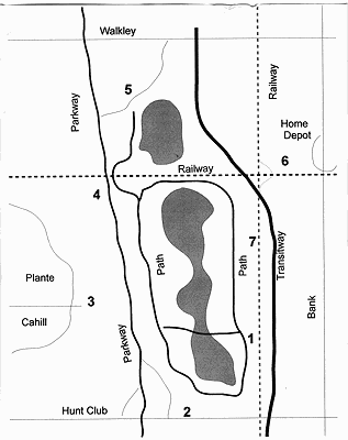
1: South Keys Transit Station
Requirements: A gate through the station railing plus steps down the hill and clean up
and lighting for the existing passage under the railway. (Used now as an informal path)
Assessment: Relatively inexpensive and involves city owned property - transitway,
railway and wetlands. This would be a start of the proposed Cahill West/Transitway connection.
There is parking at the South Keys mall and access by the transitway. It will help residents of
South Keys to discover the Wetlands. Unfortunately, it could encourage more pedestrians to
cross the Airport parkway.
2: East Side of the Hunt Club to Parkway On-ramp
Requirements: Extending the existing pavement beside the ramp over an existing culvert.
Assessment: Relatively inexpensive. Traffic dangers of walking on sidewalk or
biking along Hunt Club road and beside the on-ramp. However, many people already walk and
bike along Hunt Club road in this area. No place to park cars.
3: The end of Cahill Street West Near Plante Drive
Requirements: A bridge or underpass needs to be built to get across the Airport Parkway
plus paved or gravel path of some 150 meters.
Assessment: Relatively expensive and needs to be in the capital budget. Access to
the South Keys station would be required at the same time. Electricity is available at the
parkway. Limited parking available
4: Unused Southern Trackbed of the Railway Bridge over the Parkway
Requirements: Construction of gravel paths to and from the railway bridge and
construction of a barrier on the bridge between the path and the railway line that is used.
Assessment: Relatively inexpensive. The southern half of the bridge is 5 meters
wide and currently used to walk and ski over the parkway. Paths could go to McCarthy road and
the existing path to Plante Drive neat Avacado. The bridge is railway property.
5: Under the Walkley Off-ramp from the Parkway
Requirements: Construction of gravel paths from the end of the wetlands path to the two
Sawmill Creek culverts under the off-ramp and then up the hill to Walkley Road. Earth work so
that Sawmill creek uses the east culvert only except in case of very high water. Clean out both
culverts.
Assessment: Relatively inexpensive as no major infra-structure is required.
Provides access from Walkley Road and potentially the Brookfield path if a path is build under
Walkley at the parkway bridge. (This is possible.) No parking but near the Walkley transit
station. Lack of lighting for the culvert.
6: Behind Home Depot And Use Sawmill Creek Bridge under the Railway
Requirements: Construction of gravel path behind Bank Street Home Depot to the
Sawmill Creek bridge under the railway. This bridge has two levels. The upper level is about 8
feet high and could be used for pedestrians and cyclist.
Assessment: Relatively expensive. However, Home Depot has committed funds to
such a path. There is a small path already behind Home Depot from the Ledberry access road
where electricity for lights is available. Need to find way over the Transitway which could be
expensive. There is parking at the transit station south of the Bank Street railway bridge.
7: Greenboro O-train and Transitway Station
Requirements: Construction of a bridge or tunnel under the railway tracks and a path to
link with the wetlands paths.
Assessment: Relatively expensive and needs to be in the capital budget. Good
access via transitway, O-train and parking. An alternative: The tracks south of the Greenboro
O-train station are not used. Build a path from the station on the east side of the tracks for about
100 meters then across the tracks to the wetlands. A barrier on the tracks would prevent a train
accidentally going down the tracks. If the O-train is extended south a more permanent bridge
could be installed.
Note: The city has to access the wetlands area to service it and adjust the weirs. That is the
reason for the paved trails. Currently, the city has constructed a gravel access road off the
parkway at the Walkley off-ramp.