Hunt Club Community Names
By John Sankey
In 1876, a local landowner, William Upton, noted in his diary that “The Ottawa Hunt” was active in his area. In 1907, The Ottawa Hunt Ltd. bought most of the Upton land. After the war ended, few here remained interested in British-style fox hunting, so the club switched first to motor expeditions, then to golf. Today, there are many other uses of the name in the area and many references to foxes and golfing terms.
Gloucester Township Concession Road 5 Rideau Front, that ran along the south edge of the club lands, soon became known as the Hunt Club Road. At that time it ran from Riverside Drive (called Hogs Back Road in 1867, later the River Road) to Bank Street (then the Metcalfe Stone Road).
About 1970, the Regional Municipality of Ottawa-Carleton upgraded it to regional collector status and formalised the name Hunt Club Road. (The name may have been formalised earlier by the City of Ottawa or the Township of Gloucester.) The road to the west of the Rideau was named West Hunt Club Road to avoid having to renumber the original road, whose numbers began at the Rideau River and ran east; West Hunt Club Road numbers started at the River and ran west. Ca. 1990, the road was extended east to Hawthorne Road, in 2014 further extended to Highway 417.
Today’s Ottawa International Airport was first known, as early as 1919, as the Hunt Club Field.
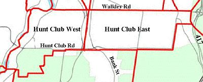
The pre-amalgamation City of Ottawa defined 50 neighbourhoods, a Hunt Club East and Hunt Club West among them. The dividing line between them was the Canadian Pacific rail line. Statistics Canada used these for reporting the 2001 Census.
Ottawa Police Services defines about 340 neighbourhoods. They restrict the name Hunt Club to two areas within the City’s Hunt Club West: Hunt Club Woods and the recently renamed Hunt Club Estate (still marked as Western Community on this map).
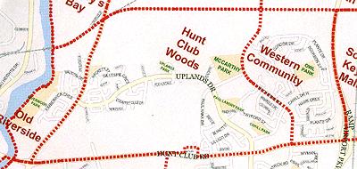
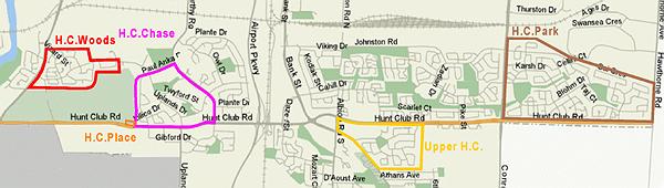
Over the years, developers have given various forms of the name to their subdivisions. Hunt Club Woods was named by Campeau, who developed the area south of Uplands Drive; Urbandale developed the portion north of Uplands. Hunt Club Chase was probably named by Campeau, but many builders were active there. Upper Hunt Club was named by Minto; Hunt Club Park by Richcraft. The City of Ottawa named Hunt Club Place.
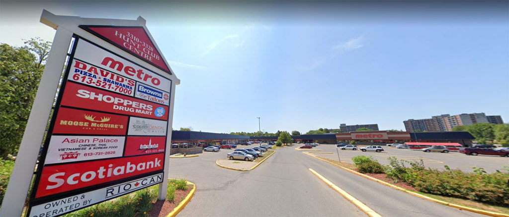
About 20 local businesses use the name, including the Hunt Club Centre, a small shopping plaza.
- Airport Parkway: built in 1972 by the NCC from just north of Heron Road to the airport, all interchanges were restricted to the southern sides to provide for access to and from the airport, but to prevent its use for intermediate access to Ottawa. In 1997 the RMOC took over the parkway and, in October 1998, opened a northern interchange at Hunt Club Road.
- Albion Line: the CN rail line forming our north boundary
- Annapolis Circle
- Arbor Green
- Archer Square: part of Country Club Estates
- Ashgrove: a rental townhouse community operated by Ottawa Community Housing
- Avocado Street: presumably named after the fruit
- Bankview Place
- Bartlett Private: formerly 1053 Hunt Club Road, developed by D.W.Kennedy in 2002
- Bayview Public School: originally Standard School #7 Gloucester Township on the Otterson farm in 1855 at the intersection of today’s Riverside Drive and Revelstoke Drive, nicknamed Bayview for it’s view, then formally named that in 1955 when Ottawa annexed the area. On demolition of the most recent school of the name in 2009, the name was given to a school on Owl Drive formerly named R.Byrns Curry.
- Beachburg Subdivision: the VIA rail line that forms our north-west boundary, originally built by Canadian Northern Railways
- Bennett Street
- Boone Crescent
- Bourbon Street
- Bowesville Road: the road from Bytown to Bowesville, a community that was established by two Bowes families in 1821 then destroyed in 1950 when the Ottawa International Airport was extended. It was a ‘forced’ road, cut directly through the bush from Ossian Hall rather than following an existing watercourse or land feature. A stagecoach began operating on it in 1834.
- Bridle Court: derived from its proximity to the Ottawa Hunt and Golf Club
- Buckingham Private: part of the Chateaus of Hunt Club
- Cahill Drive: built in 1977
- Cahill Park: named after the street it’s on
- Cardiff Private: part of the Chateaus of Hunt Club
- Cardinus Co-op
- Chambord Private: part of the Chateaus of Hunt Club
- Chancellor Court: built in 1999
- Chase Court
- Chateaus of Hunt Club: built by J.Pérez in 1984, it includes Buckingham, Cardiff, Chambord, Cheltenham and Versailles (all European names). New prices were $110,000-140,000, rentals $855/mo, slightly above the Ottawa average then of $102,084
- Chatsworth Crescent: built in 1979
- Cheltenham Private: part of the Chateaus of Hunt Club
- Claret Court
- Coady Co-op: named after Rev.Dr.Moses Coady, a founder of the Antigonish Movement, a people’s movement for economic and social justice that began in Nova Scotia during the 1920s
- Cobbler Court
- Columbia Avenue
- Condor Drive: one of a group of Western Community streets named after birds
- Country Club Drive: derived from its proximity to the Ottawa Hunt and Golf Club
- Country Club Estates: built by Urbandale in 1979, it includes Vanhurst Place and Archer Square. New prices were $67,000-79,000 (Ottawa average then $61,896)
- Crowsnest Avenue
- Darlington Private
- Dean Martin Crescent: named after an American singer, comedian & TV host (1917-1995)
- Downpatrick Road
- Ellwood: originally a hamlet on the Metcalfe Stone Road (today’s Bank Street) at the intersection of Walkley named by local surveyor Charles Wood and dairy farmer William Ellis combining their names; the name was given to the Bytown and Prescott Railway rail line built in 1854 now used by the O-Train
- Erin Crescent: built in 1979, Tartan Homes architects, RJ Nichols contractor. New prices were $53,000-58,500 (Ottawa average then $61,896)
- Finch Private
- Fox Hunt Avenue: derived from its proximity to the Ottawa Hunt and Golf Club
- Foxdown: a Campeau condominium built in 1977. New prices started at $49,000 (Ottawa average $57,032)
- Foxrun Lane: derived from its proximity to the Ottawa Hunt and Golf Club
- Gibford Drive
- Gilboa Place: built in 1979, initial rents started at $365/mo
- Gillespie Crescent: Jno Gillespie owned 50 acres in 1879 just to the west of the present street location; the current street was built in 1986
- Hackett Street: Andrew Hackett owned 150 acres in 1879 that included the present street location; the present street was built in 1989
- Hawk Crescent: one of a group of Western Community streets named after birds
- Holy Family School
- Hunt Club Chase: the area originally known by planners as the Western Community, it was built by Campeau and Sandbury Homes over 1979-83. New prices started at $87,400
- Hunt Club Creek: derived from the community name, runs from de Niverville road to the Rideau River near the Rivergate condo towers
- Hunt Club Estates: built by Tartan over 1976-81, prices in 1981 were $106,000 (Ottawa average then $64,896)
- Hunt Club Private: named after the community
- Hunt Club Place: a rental community operated by Ottawa Community Housing
- Hunt Club Woods: built by Urbandale Construction and Northern Oriole Development over 1981-3. Prices were semi-detached $87,000, singles $102,000 (Ottawa average then $71,080)
- Huntridge Private: derived from the community name, a condominium community by Campeau built in 1976
- Huntview Estates: a rental and condominium town house subdivision by Timberlay built in 1986, rents started at $695/mo
- Huntwood Court: derived from the community name; built in 1989
- Impala Crescent: named after the African antelope (possibly indirectly after the Chevrolet car that was named after the antelope)
- Kettering Private
- Killdeer Bay: presumably named after the bird
- Kimberwick Crescent: built in 1999
- Landmark: a gated adult lifestyle and senior community by Tamarack Developments in the former Dibblee Quarry started in 1988, it’s now ungated
- Leyland Private
- Lillico Drive: James & Robert Lillico settled in Gloucester in 1845; their farm became part of the greenbelt in 1956. It’s uncertain as to whether the street was named after them or one of their many descendants
- Loon Lane: one of a group of Western Community streets named after birds
- Malhotra Court: built in 1996 by Claridge Homes and named after the owner, Bill Malhotra
- McCarthy Park: containing the Hunt Club/Riverside Park Community Center, it’s named after the street it’s on
- McCarthy Road: in 1879 Donald McCarthy owned 65 acres along the road; together with his father William and older brother John, the family held a total of 225 acres in 1860. Originally the road was straight and included today’s Uplands Drive south of Hunt Club Road; it was re-routed and shortened in 1974-5 to where it is today. It was originally known as the Gillespie Road after other landowners along it; the name change to McCarthy seems to have taken place on annexation of the area by Ottawa in the 1950’s.
- Meakin Hill
- Mina Lane
- Mosswood Court
- Ossian Hall: a log house built before 1827, demolished about 1920, named after a mythical Celt who was seduced by a golden-haired fairy and lived 300 years
- Ottawa Hunt & Golf Club: in existence by 1876 as The Ottawa Hunt, it bought its current site in 1907; a golf course was built in 1924
- Owl Drive: one of a group of Western Community streets named after birds
- Owl Park: named after the street it’s on
- Pattermead Crescent: built in 1979
- Paul Anka Drive: Paul Albert Anka, born in Ottawa in 1941, became famous in the late 1950s and 1960s with hit songs like “Diana”; built in 1981
- Paul Landry Park: named in 1991 after a deaf Ottawa runner who competed internationally during the 1980’s; it was rededicated to him in 2017
- Pigeon Terrace: one of a group of Western Community streets named after birds
- Pinson Private
- Plante Drive: Jean-Baptiste Plante and his wife Matilde ran the Plante Dairy which occupied most of what became the Western Community; their access was at 2314 Bank Street over a level crossing with the CPR line now used by the O-Train. The business lasted from 1926 to 1975, when the Airport Parkway divided their lands. The present road was built in 1977-8
- Prescott Subdivision: the name given by CP to the Bytown and Prescott Railway Ellwood line now used by the O-Train
- Quarry Co-op: named for the Dibblee stone quarry it overlooked when it was built
- Quinterra: built by Tamarack and Larco in 1996-9
- Quinterra Court: named after the development; built in 1996-9
- Ratan Court
- Rhapsody Lane: built by Garand Homes
- Rich Little Drive: Richard Caruthers Little, born in Ottawa in 1938, became famous in the 1950s mimicking the voices of Prime Minister John Diefenbaker and Ottawa Mayor Charlotte Whitton
- Rideau Waterway (Canal): named by Champlain after the curtain-like appearance of the fall of the original river at the Ottawa River (then, the Grand River). The water level at Rivergate (Ossian Hall) is about 1.5 m higher than it was prior to completion of the dam at Hogs Back in 1830.
- Rivergate Way: named for the condo highrises it leads to, a gated community next to the river
- Riverside Drive: named because it runs along the Rideau river. It began as a trail from the Billings home to Ossian Hall (near Rivergate Way) about 1827, was first extended to Bowesville and called the Bowesville Road, later was extended south along the river as the River Road, re-routed to its present location in 1996
- Riverwood Park derives its name from its area, between the river and Hunt Club Wood
- Royal Hunt Court: originally Ptarmigan Court, it was renamed in the early 1980s because the silent P caused people to vainly search for it under “T”
- Royalton Private
- Sample Road
- Sawmill Creek: running from wetlands near Leitrim Road to Billings Bridge, it was originally a major stream that powered the Billings’ sawmill near today’s Transitway overpass from 1823
- Sawmill Creek Constructed Wetland: a stormwater treatment complex built over 2004-7
- Sequoia Co-op
- Shearwater Court: a rental townhome community operated by Ottawa Community Housing
- Sheflin Bridge: named after Michael Sheflin, RMOC Commissioner of Transportation; opened in 1985
- Singer Place
- Southern Corridor: the area set aside for the southern part of the ring road planned in 1950 by Jacques Gréber, but never built
- Sparrow Way: one of a group of Western Community streets named after birds
- Steeplechase
- Tannenhof Co-op
- Tattersall Way: built in 1996-9
- The Masters Drive: derived from its proximity to the Ottawa Hunt and Golf Club, it contains our most expensive housing
- Trusty Bay
- Tudor Hall: a conference and reception facility built in 1975, named by the owners
- Twyford Street
- Uplands Drive: the area was called the Uplands by early settlers as it’s one of the highest points in the area; built in 1981
- Uplands Court: a garden home community by Tartan built in 1977; new price $73,500 (Ottawa average $57,032)
- Uplands Park: named after the street it’s on
- Uplands-Riverside Park: named after the area and the street it’s on
- Uplands Sand Pits: supplied sand for industries along the Rideau Canal, later for CN to 1918, then south of where the Sheflin bridge is now was used as a swimming hole until levelled during construction of the bridge
- Vanhurst Place: part of Country Club Estates, built in 1986
- Versailles Private: part of the Chateaus of Hunt Club
- Vintage Lane
- Vizard Street: built in 1989
- Wass Junction: the rail junction between the VIA Beachburg and CN Albion rail lines, it was originally built during the 1st war to supply sand and gravel for CN construction; during the 2nd war it was resurrected to supply Uplands airport
- Waxwing Drive: one of a group of Western Community streets named after birds
- Welby Court
- Western Community: the original planners’ name for our area between Bank Street and McCarthy Road
- Wisteria Crescent
- Wisteria Park: named after the street it’s on
- Yorkberry Gate
Jack Marsala provided information on developers’ names; Glenn Clark of the Gloucester Historical Society assisted. Many street names are proposed by developers; no reason or context is recorded by the city when approving them.