The Highs and Lows of Hunt Club
How Well Do You Know Your Community
May 22, 2021 - By John D. Reid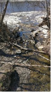 Do you recognize this place in our community? Hunt Club Creek flows into the Rideau River, just upstream from the rail bridge and the lowest point in Hunt Club, about 76 m above mean sea level.
Reach it from a trail that winds beside the creek from the north end of Rivergate Way. There’s easier access from Old Riverside Drive north of the train tracks.
Just over 1 Km from the lowest point is the highest — at 112 m — on the grounds of the Hunt and Golf Club. While there is no public access, adjacent Riverside Drive rises to 107m. The ground ascends to 119m at the airport.
Another high point in our community is north of McCarthy Road, from the Quarry Coop to Huntview Condominiums rising to 106m.
Find out the elevation where you live at https://en-ca.topographic-map.com/maps/q4e/Ottawa/
Interesting facts about our community. Thank you.